

ackground: Rising Demand for Military Electronic Sand Tables
In modern warfare, traditional command information systems often lack practical decision-support capabilities. This shortfall limits their effectiveness in operational planning and battlefield rehearsal. After-action reviews in command post exercises also suffer from insufficient terrain-based analysis and the inability to perform real-time battlefield simulations.

As armed forces worldwide shift toward precision operations—featuring precise reconnaissance, precise analysis, precise command, and precise evaluation—the need for Military Sand Table solutions has grown significantly. While some military academies and research institutes employ auxiliary decision-support tools such as wargaming systems, these platforms often focus more on tactical experiments and lack seamless integration with actual operational planning.
A Military Electronic Sand Table—also known internationally as a Tactical Sand Table, Digital Sand Table, Virtual Sand Table, Terrain Model, or Battlefield Simulation Table—bridges this gap. It delivers decision-support for mission planning, 3D terrain analysis, operational deployment visualization, and scenario-based training.
About the Digital Military Sand Table System
The Digital Military Sand Table System is built upon high-precision 3D geospatial data. It integrates core weapon platform performance parameters, enabling:
Advanced terrain data analysis and real-time 3D visualization
Terrain-based weapon effectiveness demonstrations
Visual troop deployment mapping on realistic terrain
Operational plan rehearsal with spatio-temporal conflict detection
This Tactical Sand Table platform supports operational planning for ground forces and provides an essential teaching tool for scenario-based training in military academies.

Architecture of the Interactive Virtual Sand Table System
1. System Overview
The Interactive Military Sand Table adopts a layered architecture—access layer, business layer, service layer, interface layer, and resource layer—offering:
Full-spectrum battlefield visualization
Operational plan support and decision aid
Multi-terminal access (PC, touch screen, large display)
Interoperability via multiple data communication protocols
2. Layered System Design
2.1 Access Layer
PC Workstations: Ideal for command centers and analytical staff
Touch Control Panels: Intuitive gesture-based operation for planning and real-time command
Large Immersive Displays: Panoramic visualization for high-level briefings
2.2 Business Layer
Integrated battlefield environment display (terrain, troop positions, environmental data)
Operational plan simulation, rehearsal, and evaluation tools
Multi-scale and multi-style map generation and export
Military symbology annotation for situational awareness
Real-time battlefield monitoring and updates
Multi-source data fusion for strategic analysis
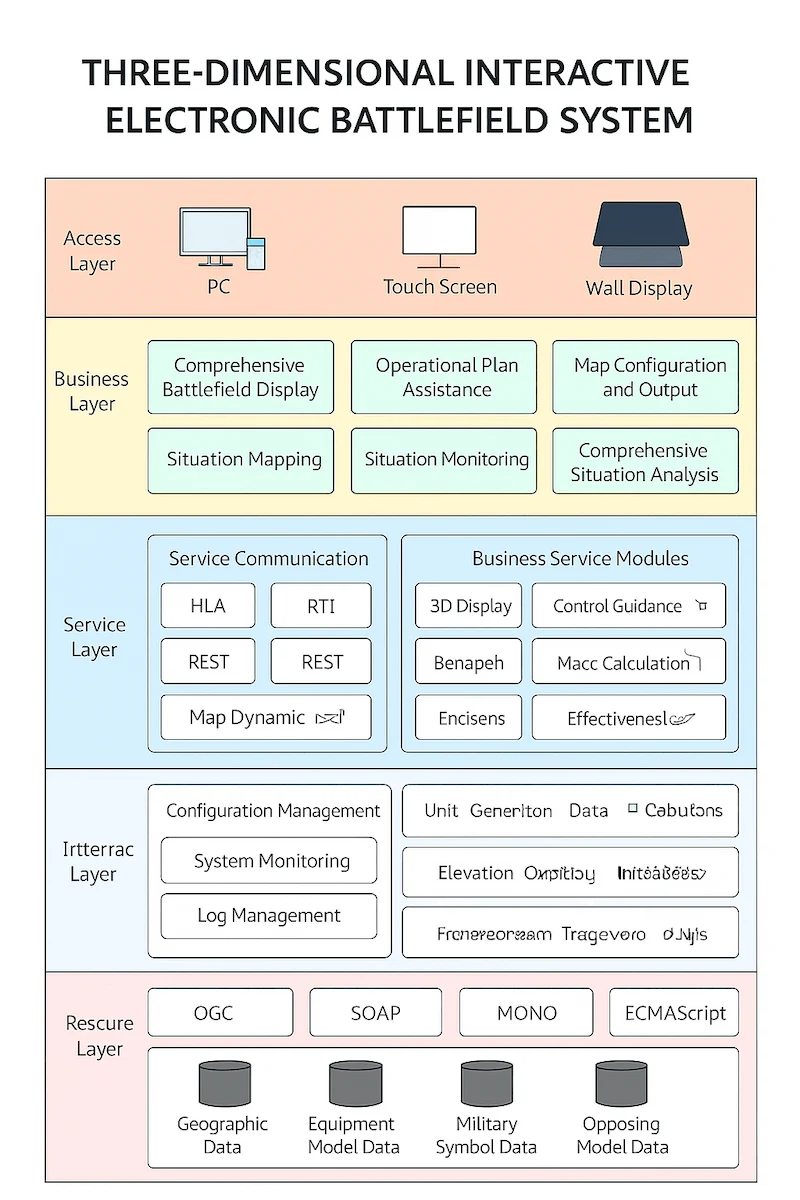
2.3 Service Layer
Protocols: HLA, RTI, REST
Modules: 3D collaborative mapping, exercise control, data analytics, path planning, dynamic simulation, combat effectiveness assessment
Support Functions: Map rendering, elevation modeling, weather simulation, ballistics calculation, firepower coverage mapping, damage assessment
Management: Configuration, monitoring, logging, user administration
2.4 Interface Layer
OGC, SOAP, MONO, ECMAScript for seamless data exchange with GIS, C2, and simulation systems
2.5 Resource Layer
Geospatial datasets, equipment 3D models, standardized military symbols, and force-on-force modeling data
Key Advantages of the Military Sand Table Platform
Comprehensive Multi-Source Display
The system fuses UAV imagery, weapon and equipment data, soldier-borne terminal data, meteorological and hydrological data, providing a Battlefield Simulation Table with realistic 3D rendering of sky, terrain, sea, infrastructure, personnel, and vehicles.
Precision Operational Marking
Multi-touch annotation on the 3D map allows users to draw tactical symbols in full compliance with PLA and NATO mapping standards.
2D/3D Linked Operations
Real-time synchronization between 2D and 3D maps, combining rapid navigation with immersive visualization.
Exercise Playback & After-Action Review

All simulation data is stored for replay, enabling commanders to analyze operational effectiveness, review battlefield decisions, and extract lessons learned.
Operational Planning Assistance
Intelligent route calculation, attack vector visualization, reconnaissance coverage mapping, dynamic firepower threat analysis, and reverse targeting to identify enemy firing positions.
Future Development Outlook for Virtual Sand Tables
Ultra-realistic 3D battlefield tours with panoramic roaming
Multi-view tactical control with picture-in-picture details
Third-party data integration for simulation exercises
Modular design supporting multiple terrain types and operational scenarios
Touch-based, barrier-free human–machine interaction
