Military Sand Table – Digital & 3D Battlefield Simulation

Intelligent interactive electronic sand table system


The Military Electronic Sand Table is an advanced decision support system designed to provide military commanders with a dynamic and interactive environment for strategic planning, combat simulation, and tactical training. Based on high-precision 3D terrain data and real-time battlefield information, the system allows commanders to simulate various combat scenarios, analyze tactical deployments, and assess potential outcomes, all within a digital interactive platform.

This innovative solution is essential for modernizing military command operations, allowing for more precise decision-making, effective training, and enhanced command effectiveness. The Military Electronic Sand Table bridges the gap between traditional sand tables and the cutting-edge needs of modern warfare, offering an interactive, real-time simulation of battlefield environments.

Military Sand Table Key Features


3D Terrain Simulation

0.1m-resolution 3D modeling / 24 weather patterns / Dynamic day-night lighting

‌Real-Time Battlefield Awareness

Satellite-GPS-BDS fusion positioning / Multi-source video feeds.

Intelligent Interactive Marking

1,000+ military symbol library / Multi-user collaboration / Gesture controls.

‌AI-Powered Decision Support

Route optimization algorithms / Spatiotemporal conflict detection / Weapon lethality modeling

Cross-Platform Combat Coordination

Multi-terminal data sync / Command broadcasting / Digital whiteboard integration.

Military-Grade Security

Domestic OS compatibility / National Encryption Standard SM4 / Custom development


Get Your Custom Quote
Liftable military electronic sand table


Functions of the Military Sand Table


The Military Electronic Sand Table is packed with advanced features that improve tactical command and battlefield awareness. Here are the core functionalities that make this system a vital tool for military operations:


3D Terrain Intelligence Screen


Integrates satellite imagery with survey data for ‌line-of-sight analysis, slope calculation, and flood simulation‌, resolving blind spots in mountain/urban warfare.


3D military electronic sandbox


Troop Deployment and Tactical Adjustments

The Military Electronic Sand Table system allows rapid troop deployment and dynamic tactical adjustments. Commanders can drag and drop units on the interactive map, instantly observing the tactical effects of repositioning. This feature helps commanders optimize troop arrangements and adapt strategies to changing battlefield conditions.


Military sand table system allows rapid troop deployment


 Military Electronic Sand Table is a crucial tool for tactical training

Tactical Training Support

The Military Digital Sand Table is a crucial tool for tactical training. It supports a variety of training modes, such as red-blue confrontation exercises, real combat drills, and mission simulations. Commanders can deploy units and simulate real-world battle scenarios in a controlled, interactive environment. This feature helps personnel improve their decision-making and tactical skills without the risks of actual combat.


3D Terrain Operation and Accurate Battlefield Visualization

With its 3D terrain capabilities, the Military Electronic Sand Table displays realistic geographic landscapes, offering commanders the ability to zoom in on detailed terrain features. Whether it’s for real-time analysis of enemy positions or understanding the terrain's influence on tactical movements, this feature provides commanders with precise, real-time insights to make informed decisions.

Military Electronic Sand Table displays realistic geographic landscapes


Multi-Level Video Surveillance and Remote Command

Integrated video surveillance allows commanders to remotely monitor operations through live footage from various battlefield locations. Whether monitoring drone footage or surveillance cameras, this feature provides comprehensive oversight of the battlefield and supports real-time command adjustments.

Multi-Level Video Surveillance and Remote Command


‌Intelligent Interactive Marking

The Military Sand Table system features a versatile and diverse annotation and drawing function, supporting the addition of 3D text, ground-level text, annotation points, lines, polygons, circles, rectangles, rally points, single arrows, and double arrows for various annotation and drawing methods. The editing interface allows for the customization of annotation point names and supports the entry of attribute information such as images, text, videos, PDFs, VR content, etc., at any location. Multiple types of data can be entered within a single annotation and can be operated and displayed separately. The system also supports the expansion of annotation styles based on user needs..

Military Sand Table system diverse annotation


Military Standard Marking and Military Geography System

Built-in 1200+ standardized military standard library, supports hotspot marking, panoramic maps, and plan management, meeting the needs of complex battlefield information marking.The system includes interactive modules such as a model library, special effects library, measurement library, analysis library, tool library, and military standard library, each of which is subdivided into various operational functions. These modules assist users in quickly deploying 3D situational awareness scenes for current events, helping leadership assess situations and make decisions in a three-dimensional, accurate, and vivid manner.

Military Standard Marking and Military Geography System


Digital Military Sand Table with the function of measurement database,providing area, distance, height, Angle, slope, triangle, coordinate and other measurement methods

Military Sand Table with the function of measurement database
BeiDou (BDS) Target Monitoring Function

‌GPS/BeiDou (BDS) Target Monitoring Function

The system receives target information including type, location, speed, direction, and alarm data transmitted from the data center via GPS and BeiDou Navigation Satellite System (BDS). It generates corresponding target models on a 3D electronic map and updates their status in real-time, while enabling command uploads through the data center to communicate with GPS and BeiDou targets.‌


Supports Offline Mode


Army Sand Table System

The Military Electronic Sand Table System consists of both software and hardware layers.The software layer includes:3D Modeling Engine: Constructs high-precision terrain, military facilities, and equipment models.Simulation System: Simulates combat unit behaviors, weapon effectiveness, and battlefield environmental changes.GIS Platform: Integrates satellite imagery and elevation data to provide geographic spatial analysis support.The hardware layer includes:Display Equipment: High-resolution LED screens or VR headsets, supporting 3D battlefield visualization.Interactive Devices: Touchscreens that support multi-user collaborative operations.

Military sand table main screen collaboration


‌0-90° Arbitrary Elevation and Hovering

The high-definition LCD screen in the middle of the military sand table can be raised and lowered at any angle between 0-90°, allowing you to watch the content from multiple angles

Military digital sand table that can be raised and lowered 90 degrees

‌Large screen and small screen unlimited size

Electronic sand table embedded in the LCD screen unlimited size and number can be customized according to user requirements.

Military digital sand table Large screen and small screen


‌Military Simulation Sand Table Many Styles Support Customization

Diversified products can be customized according to your needs

Military sand table in various styles

Applications of the Military Electronic Sand Table

The Military Electronic Sand Table is more than just a visualization tool—it's a comprehensive command simulation and tactical planning system widely applied across diverse defense and security domains. From real-time battlefield visualization in command centers to interactive training in military academies, and from defense R&D to disaster response, this advanced system provides geospatial intelligence, multi-user collaboration, and 3D terrain simulation to support mission-critical decision-making. Discover how this cutting-edge technology enhances operational efficiency, strategic planning, and cross-functional coordination in a wide range of real-world military and security scenarios.

Military Command Centers Electronic sand table

Military Command Centers

Military Electronic Sand Tables play a critical role in modern command centers, acting as a dynamic command and control system that visualizes battlefield environments in real time. With high-precision 3D terrain modeling and live tactical simulation, commanders can analyze troop deployments, assess threats, and plan operations with greater precision and speed. The platform integrates satellite imagery, geographic intelligence, and unit data to ensure informed strategic decision-making during critical military missions.
Electronic sand table Military Academies and Training Institutions

Military Academies and Training Institutions

Military Academies and Training InstitutionsMilitary training institutions utilize Military Electronic Sand Tables to elevate the quality of tactical education. Through realistic battlefield simulation and interactive mission rehearsal, cadets and officers can visualize different combat scenarios and understand the impact of terrain on decision-making. The system supports scenario-based training, enabling users to practice everything from small-unit tactics to large-scale operational strategies in a controlled, digital environment.
Electronic sand table Defense Research and Development Centers

Defense Research and Development Centers

In defense R&D centers, the Military Electronic Sand Table is a powerful simulation tool used to test and evaluate new weapon systems, battlefield technologies, and strategic concepts. It allows researchers to recreate combat scenarios, assess the effectiveness of military equipment, and simulate enemy behaviors. By combining geospatial analysis with AI-powered simulation engines, it helps accelerate innovation and reduce field-testing costs in defense technology development.
Electronic sand table Emergency Command and Disaster Response Centers

Emergency Command and Disaster Response Centers

Beyond traditional military uses, the Military Electronic Sand Table is widely applied in emergency response and disaster relief operations. Equipped with geographic information systems (GIS), the platform offers real-time terrain visualization and mission coordination tools to support rapid deployment and risk management. Whether coordinating rescue efforts during natural disasters or planning evacuation routes, the system enhances situational awareness and cross-agency collaboration.
Electronic sand table Joint Military Exercises and Drills

Joint Military Exercises and Drills

During joint drills and military exercises, the Military Electronic Sand Table serves as a real-time operational platform for simulating battlefield conditions across multiple command levels. It supports multi-user interaction and real-time data sharing, making it ideal for rehearsing joint operations between ground, naval, and air forces. This interactive training solution strengthens command coordination, improves unit response times, and enhances overall combat readiness.
Electronic sand table Defense Research and Development Centers

Border Surveillance and Strategic Defense Operations

For national security and border control applications, Military Electronic Sand Tables integrate video surveillance, GIS mapping, and battlefield analytics to monitor and respond to threats in sensitive areas. By visualizing complex terrains such as mountains, deserts, and river crossings, the system helps military forces optimize patrol paths, detect suspicious movements, and simulate rapid response strategies. This capability ensures stronger situational control over high-risk defense zones.

Military Sand Table Specifications

Model LSMT Series
Screen Size 32" - 150" (customizable based on application needs)
Resolution 4K UHD (3840 x 2160) or Full HD (1920 x 1080) options
Touch Technology Multi-touch capacitive screen, supporting up to 10 simultaneous touch points
Screen Adjustability 0° to 90° tilting; height-adjustable stand for flexible viewing1040x440x100mm
Operating System Compatibility Windows, Android, and Linux support for versatile software integration
CPU Intel Core i5/i7 (configurable for processing needs)
Graphics Card Integrated GPU; optional high-performance GPU for intensive 3D applications
RAM 8GB standard, upgradeable to 16GB or 32GB
Storage SSD 256GB standard, expandable up to 1TB
Connectivity HDMI, USB, Ethernet, Wi-Fi, Bluetooth for enhanced compatibility and ease of data transfer
Control Mode USB/Network/WIFI 4G/5G optional
Power Supply 110-240V AC input with built-in power adapter
Secondary Screen Control Optional synchronized display support for dual-screen interaction
Color Options Customizable frame and base color options
Applicable Standards Optional synchronized display support for dual-screen interaction
Lighting System Ambient LED lighting with adjustable brightness
Additional Features

Hydraulic lifting system (optional),

VR/AR compatibility for extended reality experiencesVR/AR,

Real-time data integration support,Remote control operation

About Us

Leading Original Manufacturer of Military Sand Table

Specialized in the field of intelligent information equipment for more than 10 years

About Lumi Link


Shenzhen Lumi Link Technology Co., Ltd. was established in October 2014,We are a modern high-tech enterprise focusing on the field of intelligent information equipment for more than ten years, specializing in the provision of consoles, operating consoles, dispatch consoles, control centers, and other products and solutions to the integrated service provider.


As a leading original manufacturer of electronic sand tables, our company specializes in the design, customization, and development of high-quality interactive 3D display systems. With years of experience, we are dedicated to providing cutting-edge solutions across various industries, including education, real estate, command centers, and exhibitions.


Our expertise lies in tailoring military sand tables to meet specific client requirements, from fully customizable 3D models to adjustable display options. We pride ourselves on our advanced R&D capabilities and strict quality control, ensuring each product meets the highest standards of performance and durability. Our in-house production and engineering teams are equipped to handle complex projects and deliver reliable, immersive experiences that align with modern digital visualization needs..

  • 10years+

    10 years + industry experience

  • 500+

    500+successful cases

  • 20+

    20+ (export to) countries and regions

  • 200+

    200+ Achievement customer

  • 20+

    20+patents

  • 3000+

    3000m²production area

Military Sand Table Manufacturer

Our real-time product demonstrations showcase the interactive 3D displays in action, while our factory tour highlights our commitment to quality, innovation, and customization. From the hands-on assembly process to final product testing, see firsthand how we bring data visualization to life, tailored for industries worldwide..

Answers To Your Questions

What is a Military Sand Table?

A Military sand table is a simulation tool used by military commanders to represent battlefield terrain for tactical and strategic planning. The Military electronic sand table goes a step further by using advanced technology to create interactive, 3D simulations, allowing commanders to visualize battle scenarios, deploy units, and make informed decisions based on real-time data.

What’s the difference between a traditional Military Sand Table and a Military Electronic Sand Table?

 A traditional Military sand table uses physical models to represent terrain, whereas a Military electronic sand table integrates digital technology to provide interactive 3D simulations. The electronic version offers real-time data, satellite integration, and the ability to simulate various battlefield scenarios, providing a more advanced and dynamic training experience.

How much does a Military Electronic Sand Table cost?

A Military Electronic Sand Table is a customized product, so it's difficult to provide an exact price. The cost depends on the specific requirements of the customer, as everyone's needs are different, which leads to different prices. However, there are many factors that influence the price of a digital sand table, such as the software system, the level of detail in the map, hardware configuration, whether it includes touch interaction features, and the display format of the sand table. All of these directly affect the price of the digital sand table.

The benefits of using a military sand table?

The Military electronic sand table offers several benefits, including real-time battlefield simulation, interactive decision-making, strategic path planning, and enhanced training capabilities. It allows for multi-user collaboration, ensuring that multiple commanders can coordinate their efforts effectively during joint exercises or complex operations.

How does a Military Sand Table help with tactical training and simulation?

 A Military sand table is a powerful training tool that allows military personnel to simulate real-world combat scenarios. With the Military electronic sand table, users can interact with 3D terrain models, test different tactics, and receive real-time feedback. This enhances strategic thinking, spatial awareness, and decision-making skills, improving overall combat readiness.

Can a Military Electronic Sand Table be used for joint military exercises?

Yes, the Military electronic sand table is ideal for joint military exercises as it allows multiple commanders from different units to collaborate and make tactical decisions in real-time. By simulating battlefield conditions and providing instant feedback, it enhances coordination and communication across different branches of the military.

What is a Military Sand Table Model, and how is it different from an Electronic Sand Table?

A Military Sand Table Model is a tool used for military training and combat planning. It is typically built based on topographic maps, aerial photos, or actual terrain, using sand, military pieces, and other materials to scale. It is primarily used to simulate battlefield layouts, troop deployments, and other scenarios, helping commanders conduct military exercises and tactical drills.


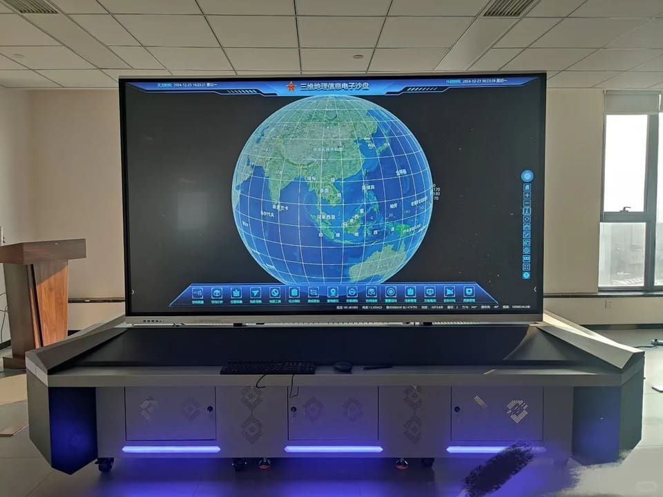
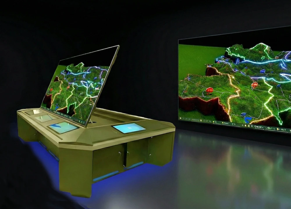
An Electronic Sand Table, on the other hand, is a display system that combines traditional sand table models with modern electronic technology. It is based on the traditional sand table but incorporates advanced technologies such as sound, light, electric, multimedia, computer control systems, and large-screen projection systems. The electronic sand table uses the small area of a physical sand table to correspond with a large-screen display, providing vivid and realistic dynamic information presentations. It is widely used in military, urban planning, environmental management, architectural design, and other fields.


What types of military units benefit most from using a Military Sand Table?

 The Military sand table is beneficial for a wide range of military units, including command centers, tactical training units, R&D departments, and disaster response teams. The Military electronic sand table is especially useful for large-scale military exercises, strategic planning, and simulation of complex operations across multiple domains (land, air, sea).

Can the Military Electronic Sand Table be customized for specific military needs?

Yes, many Military electronic sand tables are highly customizable to meet the specific needs of different military units. Whether it's for tactical training, mission planning, or crisis response, the system can be adjusted to simulate different environments, integrate various weapons systems, and support multiple languages and command structures.

How does a Military Electronic Sand Table improve decision-making in combat?

The Military electronic sand table enhances decision-making by providing commanders with a detailed, interactive view of the battlefield. Through real-time simulation and strategic scenario testing, commanders can evaluate the impact of different decisions and tactics before implementing them on the field, leading to better-informed choices and reduced risks during actual operations.

Contact Us


SHENZHEN LUMI LINK TECHNOLOGY CO., LTD.  

Address :  No. 6 Jinsha Industrial Road, Kengzi Street, Pingshan District, Shenzhen China 518118
International Sales Tel :(+86 ) 150 1358 8039
Domestic Sales Tel : (+86) 150 1358 8039
Tel : 0755-28227676
E-mail : sales@szlumilink.com


position,.jpg

Leave a message

Want to learn more about applications for electronic sand tables, military sand tables, or 3D virtual sand tables? Leave a message, and we'll provide expert guidance!

WhatsApp Chat