


In the high-stakes, hyper-dynamic environments of modern warfare, disaster response, and national security, the speed, precision, and accuracy of decision-making are the ultimate determinants of operational success. For decades, military commanders, emergency management directors, and tactical planners have relied heavily on physical sand tables to visualize terrain, map out strategies, and coordinate multi-domain operations. However, the modern digital battlefield and the unpredictable nature of global emergencies demand a profound shift. Modern warfare requires a comprehensive transformation from static, physical models to highly dynamic, intelligent, and data-driven digital ecosystems.
To meet and exceed the complex demands of these modern operations, the Next-Generation Interactive Electronic Sand Table has emerged as the ultimate Command and Control (C2) solution. By seamlessly integrating Geographic Information Systems (GIS), artificial intelligence (AI), and military-grade simulation engines, this C2 platform bridges the critical gap between traditional tactical planning and the cutting-edge needs of modern forces. This article explores how this technology is redefining the battlespace, eliminating data silos, and providing an unprecedented tactical edge for both fixed command centers and deployed mobile units.
Overcoming the Critical Pain Points of Traditional Command Tools
To fully grasp the search intent of defense contractors, government agencies, and military academies seeking digital C2 platforms, it is essential to analyze the profound pain points associated with legacy systems. The evolution of Command and Control has long been hindered by the inherent limitations of physical, analog models.
Commanders and emergency responders today face several critical challenges when utilizing traditional physical sand tables:
- Slow Production and Lack of Agility: Traditional physical models take weeks to construct from scratch. More importantly, they cannot be updated in real-time as the situation on the ground changes, which severely limits a command team's responsiveness in highly dynamic, fast-paced operational environments.
- Dangerous Data Silos: Analog setups are fundamentally incapable of overlaying multi-dimensional digital data streams. They cannot integrate live weather updates, real-time GPS unit positions, or incoming intelligence feeds, which ultimately creates a fragmented, incomplete picture of situational awareness.
- Limited Analytical Capabilities: Old methodologies rely heavily on manual interpretation and intuition. They lack mathematical deduction, automated terrain analysis capabilities, and predictive modeling, forcing planning teams to rely on guesswork rather than hard data.
The strategic imperative and market demand for digital transformation are exceptionally clear: modern operators require real-time dynamic rendering, multi-dimensional data integration, and intelligent analytical tools to maintain overmatch and situational dominance.
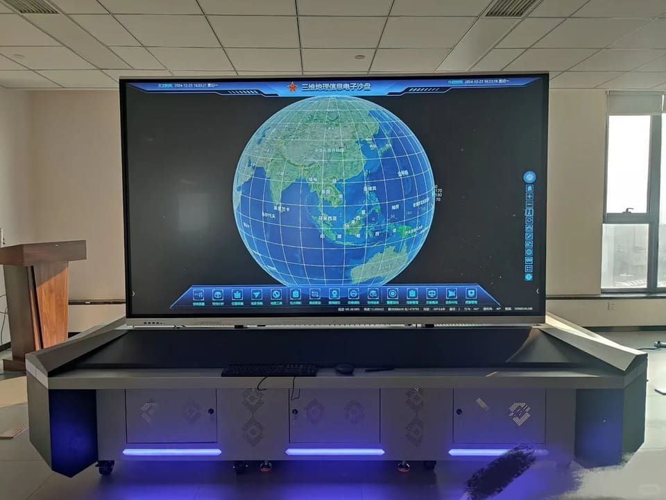
Defining the Next-Generation Electronic Sand Table: Pixels Over Sand
The Next-Generation Electronic Sand Table is a unified holographic command platform that quite literally replaces physical sand and plastic markers with high-resolution pixels and digital assets. It utilizes a large-format, touch-sensitive interactive surface to render incredibly detailed 3D geospatial data.
Crucially, this system integrates seamlessly with existing Battle Management Systems (BMS), allowing commanders to visualize complex terrain, track friendly and hostile assets in real-time, and simulate mission outcomes with the simple swipe of a finger. By replacing the slow, manual updating process of the past, commanders can now achieve total battlespace awareness in a fraction of the time.
Core Capabilities Revolutionizing the Battlespace
The technological foundation of the electronic sand table is built upon several core pillars, each meticulously designed to optimize situational awareness, reduce cognitive load on operators, and accelerate tactical execution.
1. Unprecedented 3D Terrain Visualization and Rendering
The system offers high-precision terrain replication using DEM (Digital Elevation Model) and DOM (Digital Orthophoto Map) data. This is combined with ultra-high resolution satellite imagery—capable of reaching an astonishing 0.1-meter resolution—and highly accurate digital elevation models. This highly immersive 3D visualization provides commanders with an intuitive, immediate spatial understanding of complex operational environments, allowing them to instantly generate terrain for rapid response missions within minutes rather than weeks.
2. Multi-Source Intelligence Fusion
To permanently break down dangerous data silos, the platform provides the seamless integration of multiple intelligence sources, ensuring comprehensive and unified battlespace awareness. The platform achieves this through:
- Real-Time Tracking: Fusing BeiDou and GPS positioning feeds to constantly monitor the exact locations of personnel, vehicles, and assets.
- Live Intelligence: Integrating Unmanned Aerial Vehicle (UAV) live feeds and multi-source video positioning directly onto the 3D map.
- Environmental Context: Overlaying vital meteorological data, weather patterns, and environmental intelligence to foresee potential natural disruptions to military or rescue operations.
3. AI-Powered Dynamic Wargaming and Simulation
Moving far beyond static planning, the platform empowers commanders with built-in, military-grade simulation engines for real-time combat assessment, strategic planning, and predictive analytics. The system supports robust tactical functions including:
- Line-of-Sight (LOS) Analysis: Providing 360-degree visibility assessments to determine targeting viability and tactical advantage.
- Weapon Range Fans: Mapping the effective range and coverage of various weapon systems or communication nodes.
- Viewshed Mapping and Elevation Profiling: Optimizing observation points and calculating slopes for troop or vehicle movement.
- Logistics and Route Optimization: Utilizing pathfinding algorithms to determine the shortest paths, optimize fuel consumption, and analyze terrain trafficability while ensuring threat avoidance.
4. Immersive Multi-Touch Interaction and Custom Annotation
The user interface supports intuitive multi-touch control, enabling multiple officers to collaborate simultaneously—drawing routes, establishing potential kill zones, and marking defensive perimeters directly on the screen. The system supports a massive variety of custom annotation and plotting methods, including 3D text, clamped-to-ground markers, and over 1,300 vector military standards. Users can embed rich attribute data—such as situational images, text documents, videos, PDFs, and even VR content—at any designated location on the map, creating a deeply informative operational picture.
The Tactical Portable Edge: Field-Ready Emergency Command
While large-scale, fixed installations utilizing 4K or 8K UHD multi-touch LED tables are perfect for joint operations centers, modern missions require supreme agility in the field. To address the realities of austere environments, the Portable Emergency Command Electronic Sand Table System (Overseas Market Edition) was engineered.
This ruggedized, highly mobile workstation transforms traditional electronic sand tables into a portable powerhouse for outdoor reconnaissance, disaster rescue command, and field exercise operations. It is built to operate flawlessly in areas where infrastructure has been destroyed or never existed.
Unrivaled Hardware Built for Extremes
The portable edition is an engineering marvel designed for the harsh realities of field operations:
- True Independence: The system does not rely on external network communication or power sources. It is equipped with a massive 13400mAh + 64000mAh battery array that ensures continuous operation for approximately 8 hours during power failures.
- Military-Grade Ruggedization: The equipment is housed in a CNC processed aluminum alloy chassis with a surface sandblasting oxidation treatment. The workstation itself weighs only 7kg, with the total ruggedized tactical case kit weighing 17kg.
- Outdoor Display: It features a 15.6-inch, 1920x1080 resolution touch screen with 500cd highlighting, making it perfectly legible even in bright, outdoor light environments.
- Massive Computing Power: To process complex 3D renders on the fly, the portable unit packs a 16-core, 24-thread CPU, an independent graphics card with 16GB of video memory, 64GB of RAM, and a combined 2TB + 4TB SSD storage capacity.
Global Localization and Data-Compatible Carrying Capacity
A major pain point for international operations, coalition forces, and overseas enterprise asset management is the language barrier and the lack of high-quality local mapping data. The Overseas Market Edition aggressively solves this by supporting local languages and providing offline high-definition satellite images, DEM terrain maps, and traffic road network maps for regions across the globe. The software features native map data interfaces explicitly localized for various languages, including Russian, Ukrainian, Arabic, Vietnamese, Kazakh, and Persian.
Furthermore, the system boasts an incredible data-compatible carrying capacity. It natively supports the batch loading and automatic 3D globe positioning of:
- Drone-captured aerial orthophotography and oblique photography models.
- Ground VR street view data, panoramic VR data, and mass coordinate positioning for smartphone-captured photos.
- Classified internal asset distribution maps, boundary line maps, and vector maps of specific target areas.
- Manually constructed Building Information Modeling (BIM) data, man-made structure models, and laser point cloud models.
Uncompromising Security and Absolute Data Sovereignty
In the defense, intelligence, and emergency management sectors, data leaks are unacceptable. The system architecture of the Next-Generation Electronic Sand Table is fundamentally built around absolute data sovereignty and national security.
The platform guarantees zero foreign dependencies by being fully compatible with domestic CPUs, GPUs, and Operating Systems. To prevent external cyber threats, it supports offline, air-gapped server deployment, ensuring complete network isolation. All critical data is secured using military-grade encryption standards, including AES-256 and the National Encryption Standard SM4. Most importantly, clients are guaranteed complete source code transparency with a 100% controllable code base, enabling exhaustive security audits and completely eliminating hidden vulnerabilities or unauthorized access channels.
Strategic Applications and a Proven Track Record
The operational implementations of this technology are vast and transformative across various sectors.
In Military Education and Training, academies utilize the platform to transition from abstract theory to immersive virtual combat experiences. Instructors re-enact classic historical campaigns with dynamic timelines, conduct tactical topography analysis, and run simulated Red vs. Blue confrontation exercises with AI-powered opposing forces. Educational metrics highlight massive improvements: a +85% increase in tactical comprehension, a +92% increase in retention rates, and a +67% increase in decision speed among cadets.
For Operational Command and Joint Operations Centers, the platform enables rapid pre-war simulation, risk matrix visualization, and the deduction of multiple courses of action (COA). Case studies involving Army Combined Brigades demonstrated a +40% increase in deduction efficiency, a -65% reduction in planning time, and a +90% boost in decision confidence.
In Emergency Management, such as provincial flood control command, the system destroys inter-departmental barriers. By implementing a unified "One Map" command platform, agencies achieve real-time data fusion, allowing for flood simulation, water level impact analysis, and rapid, coordinated response during critical crises.
Conclusion: Transform Your Command Capabilities Today
The era of static, physical sand tables and fragmented, slow-moving paper maps is definitively over. The Next-Generation Interactive Electronic Sand Table—whether deployed as a massive, multi-touch 4K holographic display in a fixed military headquarters or carried in a ruggedized, battery-powered tactical case into a volatile disaster zone—represents the absolute pinnacle of modern decision support systems.
By flawlessly fusing high-resolution 3D geospatial data, real-time intelligence feeds, AI wargaming simulations, and ironclad, air-gapped security, this technology transforms command intuition into highly quantifiable, validated strategic advantages. For military units, government agencies, and global enterprises looking to secure their operational future and drastically improve response times, the digital battlefield is no longer just a theoretical concept—it is a deployable, field-tested reality ready to be integrated into your command structure.
